Educating a new generation of lake leaders
About the author: My name is Karin Swanson and I am a student of the Yahara Watershed Academy. I work for Clean Lakes Alliance as the Marketing and Communications Associate Manager and I am a Meteorologist. I am sharing my journey through the Academy in an effort to expand our community’s knowledge and passion for the Yahara River Watershed.
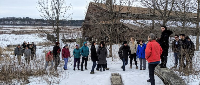
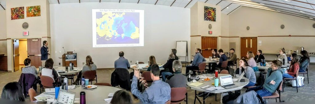
The second class of the Yahara Watershed Academy began on March 12th with some sunshine and the promise of warmer temperatures. The forecast held a marked improvement over February’s class, which took place during the biggest snowstorm of the season. Our cohort of 25 Academy students met bright and early at the University of Wisconsin Arboretum as birds chirped welcoming words for our arrival.
The Yahara Watershed Academy is made up of five day-long courses once a month, with students graduating in June. The Academy involves a partnership with the UW-Madison Nelson Institute for Environmental Studies and Edgewood College. Graduates will have received the knowledge and skills to become a network of informed leaders for our watershed.
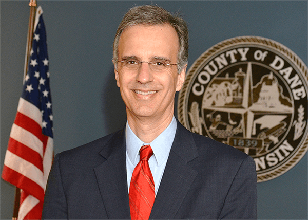
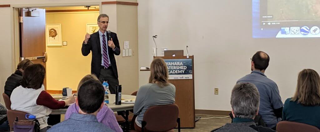
Dane County Executive Joe Parisi addresses water quality and sustainability
“Nutrient loading from phosphorus is the biggest challenge we see for our lakes.”
Joe Parisi, Dane County Executive
Dane County’s stormwater problem
Dane County Executive Joe Parisi gave the first Yahara Watershed Academy presentation of the day, speaking about Dane County’s cutting-edge projects addressing water quality, sustainability, and climate change. “Nutrient loading from phosphorus is the biggest challenge we see for our lakes,” explained Parisi. “The County will be focused this summer on the flow of the lakes. We need to continue to manage how the water makes its way through the lakes. I’d like to invest in more green infrastructure.”
Parisi explained how the stormwater management system in Dane County is one of the biggest problems our lakes face. Rain that falls on Greater Madison’s urban areas washes toward our storm drains, which directly connect to our lakes.
“We have a stormwater system that’s designed to take every drop of water that hits the ground and wash it toward the lakes. This takes every bit of sediment and washes it into our lakes.”
Joe Parisi, Dane County Executive
Stormwater in the Yahara Watershed
Dane County is working on stormwater redesigns to combat this problem, but until an entire overhaul happens, phosphorus will continue to impact our lakes and water quality. “Everything that goes into Lake Mendota goes through the entire chain of Yahara Lakes,” explained Parisi.
Lake Mendota is located at the northern edge of the Yahara River Watershed, and the runoff that flows into Lake Mendota eventually makes its way through the chain of lakes, also impacting Lakes Monona, Waubesa, and Kegonsa.
“Suck the Muck”
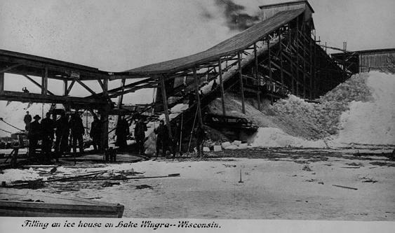
Dane County is focused on many efforts to offset our community’s impact. Most recently, a large project commonly referred to as “Suck the Muck” has been working to deal with the legacy phosphorus affecting our lakes. There is a huge source of phosphorus that’s already in the streams and waterways of Dane County. The accumulated sediment is a legacy of past farm runoff problems and has been building up for more than 100 years, but is being addressed today through best practices. The phosphorus-laden sediment is thick throughout the Dorn Creek region, and ends up washing into our lakes.
“Suck the Muck” is working to get rid of the phosphorus-laden sediment by hydrologically dredging the creek bed. This is part of a four-year pilot program to clean 33 miles of streams. In the end, habitats will be rehabilitated, and a fish spawning and wildlife area will be restored.
Sustainability in Dane County
Dane County has been pioneering additional projects that will increase the County’s sustainability impact. The County has built and will continue to build manure digesters. It’s also near completion on a county landfill gas processing system that will convert landfill methane gas and farm digester biogas into a renewable source of electric energy. In addition, Dane County has become home to many of the largest solar arrays in Wisconsin, including the Dane County East Garage, the Dane County Regional Airport, and the Dane County Jobs Center.
Joe Parisi wrapped up his presentation by telling the class, “I feel blessed to have this job.” He says he is proud of what Dane County has accomplished.
“Salt and Our Lakes”
The second presentation of the day came from Hilary Dugan, a professor of limnology in UW-Madison’s Center for Limnology and the UW Department of Integrative Biology. She shared her expertise about how road salt is impacting our lakes and streams.
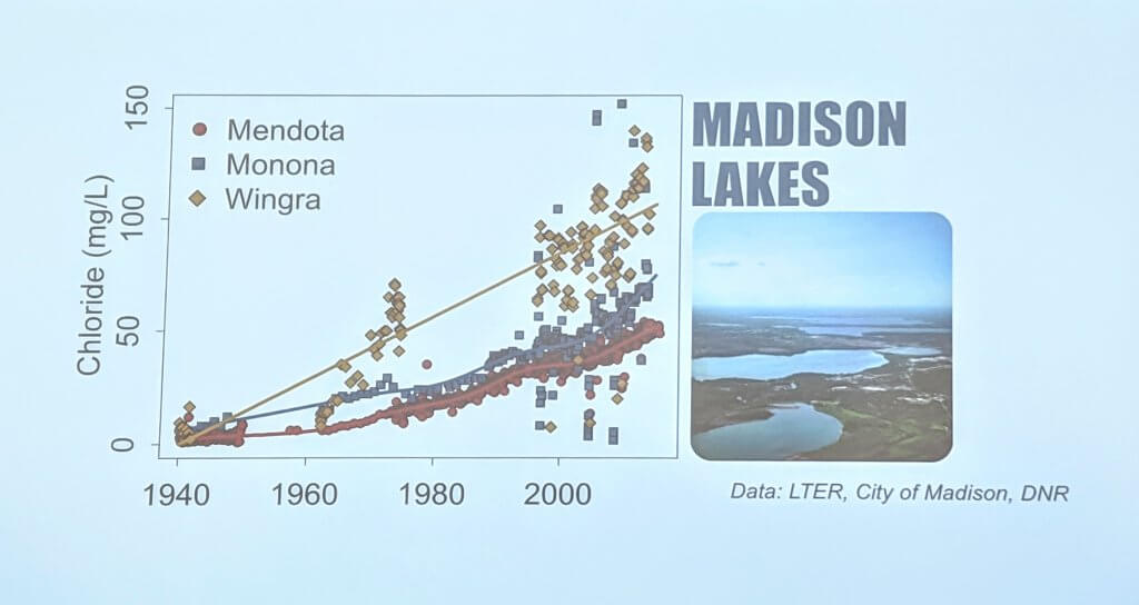
Chloride concentrations are rising
Too much chloride in our lakes can become toxic to sensitive aquatic life at high concentrations, breaking down the natural ecosystem of our lakes. Historically, communities didn’t focus on the amount of salt used on roadways because it didn’t greatly affect city budgets. However, salt concentrations have been increasing in our lakes, and people are changing their views of road salt.
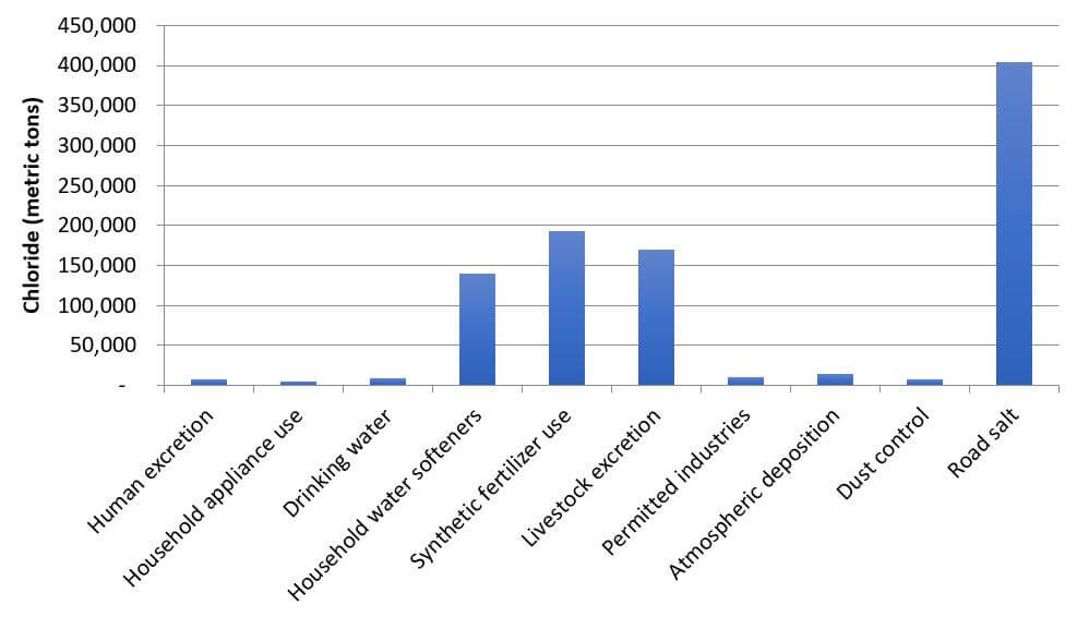
Chloride sources
While the largest source of chloride in our lakes is from road salt, other salt sources contribute to the problem. Salt may originate from synthetic fertilizer use, household water softeners, livestock excretion, and more.
Chloride can get flushed out of lakes, but that can take a long time. The flushing rate of Lake Mendota is 4.4 years. This is the time it takes to completely replace the water volume of the lake. Lake Monona is smaller and therefore has a shorter flushing rate of 9.5 months. Meanwhile, even while flushing is occurring, salt continues to enter our lakes.
Chloride pollution
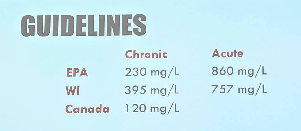
Did you know, it only takes one teaspoon of salt to pollute five gallons of water? This equals a salt concentration of 230 mg/L, which is considered to be a chronic problem by the Environmental Protection Agency.
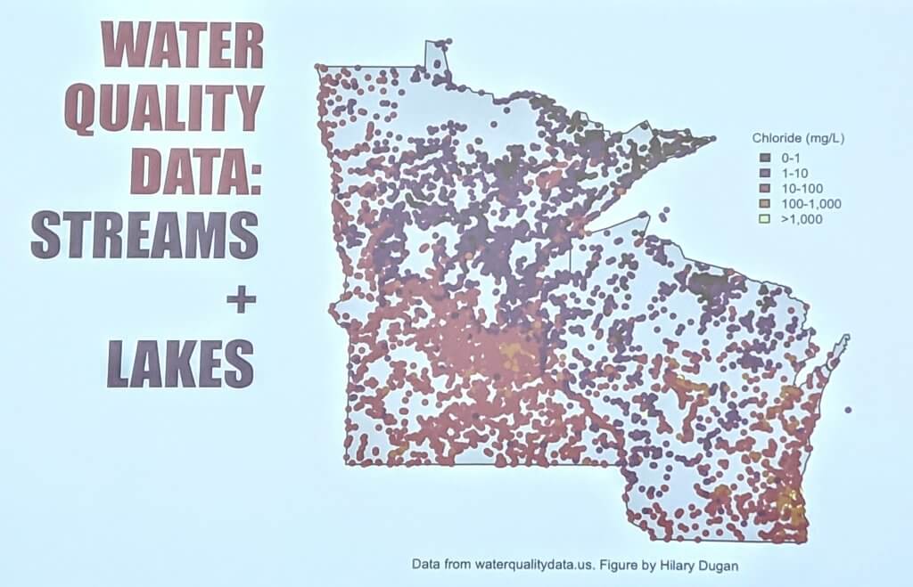
Salt (chloride) concentrations across Wisconsin and Minnesota are highest in lakes surrounding metropolitan areas. Other areas reporting high concentrations are along major interstates, such as Interstate Highway 94.
Solving the salt problem
The best way to help our lakes is to use less salt. One way road departments can help is by choosing to brine roadways instead of using rock salt that bounces off the roads and has a slower melting time. Another way you can help from your own home is by making sure your water softener doesn’t overuse salt.
“Salt in our lakes is a problem we can solve.”
Hilary Dugan, UW Center for Limnology
Additional resources
- Read more from the Center for Limnology about brine use
- Read more from Wisconsin Salt Wise
- Salt use information from Clean Lakes Alliance
- Journal article, “Salting our freshwater lakes,” by Hilary Dugan
Impacts of a changing environment
Stephen Vavrus is a Senior Scientist in the Nelson Institute Center for Climatic Research at the University of Wisconsin-Madison. Vavrus is also Co-Director of the Wisconsin Initiative on Climate Change Impacts (WICCI). His presentation focused on global and local climate change.
A changing climate
During the last ice age, which took place around 20,000 years ago, the global average temperature was only about five to six degrees colder than it is now. This temperature difference doesn’t seem like much, so how can we put temperature changes into context so that people will understand the changes and their impacts?
Recent years have been some of the warmest on record. The earth had record high global temperatures in 2014, 2015, and 2016. 2017 was the third warmest year on record, and 2018 went on record as the fourth warmest. Global temperatures show that the earth was in a cool phase from 1880-1939. A transition phase took place between 1940 and 1976, followed by a warm phase which began in 1977 and is continuing today.
Lake ice and climate change
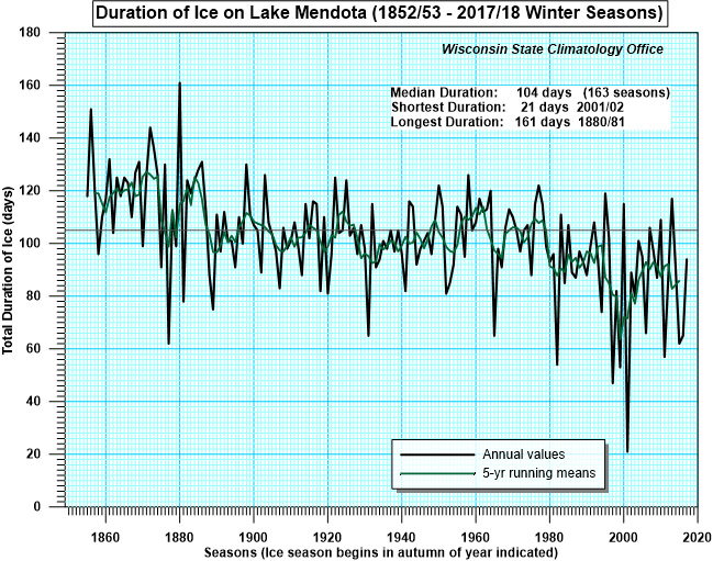
Locally, lake ice can be used as an indicator of climate change. Lake ice changes have tangible impacts, including ecological, recreational, economic, and aesthetic influences.
Ice duration records of Lake Mendota have been consistently kept from the winter of 1852/53 through the present day. Over 163 seasons, Lake Mendota has remained frozen a median duration of 104 days. The longest duration on record was 161 days in 1880/81. The shortest duration was only 21 days in the 2001/02 winter season. Most of the shortest duration seasons have been recent. Scientists project one-third of Madison’s winters will be ice-free by the end of this century!
Resources – how can you help?
- Drawdown: The Most Comprehensive Plan Ever Proposed to Reverse Global Warming – book by Paul Hawken.
- 10 Steps You Can Take to Combat Global Warming – article from The Washington Post
- Focus on Energy
Ripple Effects
Christal Campbell and Susan Sandford of the Dane County Land and Water Resources Department gave the next presentation of the day about the Ripple Effects website. Ripple-effects.com is a creation of Dane County Land and Water Resources Department and the Madison Area Municipal Stormwater Partnership (MAMSWaP), which involves 21 municipalities working together to reduce stormwater impacts to Dane County lakes, rivers, and streams.
Ripple Effects resources
The educational efforts of Ripple Effects include Plant Dane, WI Salt Wise, Leaf-free Streets for Clean Waters, as well as information about rain gardens and rain barrels, erosion control, storm drain marking and murals, home and lawn care resources, and more! Teachers may use the Enviroscape Watershed Model to help teach about human impacts on our watershed.
Another great teaching resource on the site is a video that provides information about stormwater. It explains where our stormwater goes and talks about actions we can take to prevent stormwater pollution.
Yahara Pride Farms
Pat Murphy of Yahara Pride Farms spoke to our Yahara Watershed Academy cohort about how farmers are helping reduce the amount of phosphorus that reaches our Yahara lakes. Yahara Pride Farms is a nonprofit founded in 2011, in partnership with Clean Lakes Alliance. It’s a group of farmers who came together to help improve the water quality in our watershed, while continuing to balance the profitability of farms.
Yahara Pride Farms is working on conservation practices such as cover crops, vertical manure injection, strip tillage, and more. Their efforts have reduced “edge-of-field” phosphorus loss by 24,802 pounds since 2012. One pound of phosphorus can generate 500 pounds of algae in our lakes.
“Phosphorus comes from all corners of the watershed. We need to all come together and try to improve every year.”
Pat Murphy, Yahara Pride Farms
Yahara CLEAN
In 2008, Dane County, City of Madison, Wisconsin Department of Natural Resources, and Wisconsin Department of Agriculture, Trade, and Consumer Protection launched a lake cleanup partnership called Yahara CLEAN (Capital Lakes Environmental Assessment and Needs). In 2010, the group released a report outlining 70 recommendations to rehabilitate water quality, reduce phosphorus, and improve beach safety (referred to as “Yahara CLEAN 1.0”).
In 2012, Clean Lakes Alliance reconvened the coalition of partners and hired an engineering firm to identify the 14 most cost-effective, ready-to-implement projects and practices to help reach a 50% phosphorus-reduction goal. The result was the Yahara CLEAN Strategic Action Plan for Phosphorus Reduction (referred to as “Yahara CLEAN 2.0”). The Yahara CLEAN goal to reduce phosphorus loading by 50% will result in doubling the number of clear, algae bloom-free days on our lakes.
An evolving watershed
History tells us that Lake Mendota once boasted white sand with water so clear you could see all the way to the bottom of the lakebed, even in areas of very deep water. However, years of phosphorus runoff from both rural and urban locations has changed the water quality of our lakes. In 1900, people were piping raw sewage into Lake Monona, and the link to poor water quality had become well established. However, it took another 70 years for treated wastewater to be routed around the lakes.
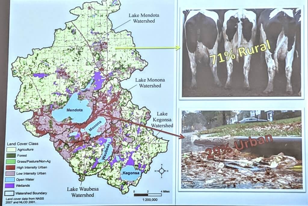
Currently, all of the Yahara lakes are considered to be federally impaired, and the primary culprit is phosphorus. 71% of the planned phosphorus reductions will need to come from rural locations, and 29% will need to come from urban locations. Clean Lakes Alliance is working on actions to achieve a 50% overall phosphorus reduction as quickly as possible.
UW-Arboretum: Science-based land management
Karen Oberhauser is the Director of UW-Madison’s Arboretum and a professor in the UW Department of Entomology. Her Yahara Watershed Academy presentation focused on the land-management practices of the Arboretum. UW-Arboretum grounds include 1,700 acres, of which 1,200 acres are in Madison.
Oberhauser is working with other staff members to make sure Arboretum land management is well planned. Their research is ongoing, involving long-term monitoring of prairies and other vegetation, fire ecology, persistence of native species plantings, stormwater management, and monitoring invasive species such as jumping worms.
Touring the UW-Arboretum
Oberhauser finished her presentation by giving the class a tour of the UW-Arboretum. She explains how nearly every tree grown in Wisconsin also grows at the Arboretum. The Arboretum’s Curtis Prairie covers 73 acres south of the Visitor Center, and was planted in the 1930s and 1040s. The Arboretum believes Curtis Prairie is the first restored prairie in the world!
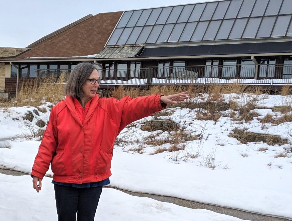
Of the 1,200 acres of UW-Arboretum in Madison much of the land is natural, but unfortunately some land is infested with invasive species. The Arboretum’s management priorities focus first on cleaning up lands that are high quality and those with historical importance. Some of the Arboretum priorities for 2019 include brush clearing, burn ecology, stormwater management, and increasing fish and wildlife habitat.
UW Arboretum and stormwater management
David Liebl is the former statewide stormwater management specialist for UW-Cooperative Extension and is currently the Co-Director of the Wisconsin Initiative on Climate Change Impacts. He is working on new and innovative approaches to stormwater management at the UW-Arboretum.
Stormwater recipient
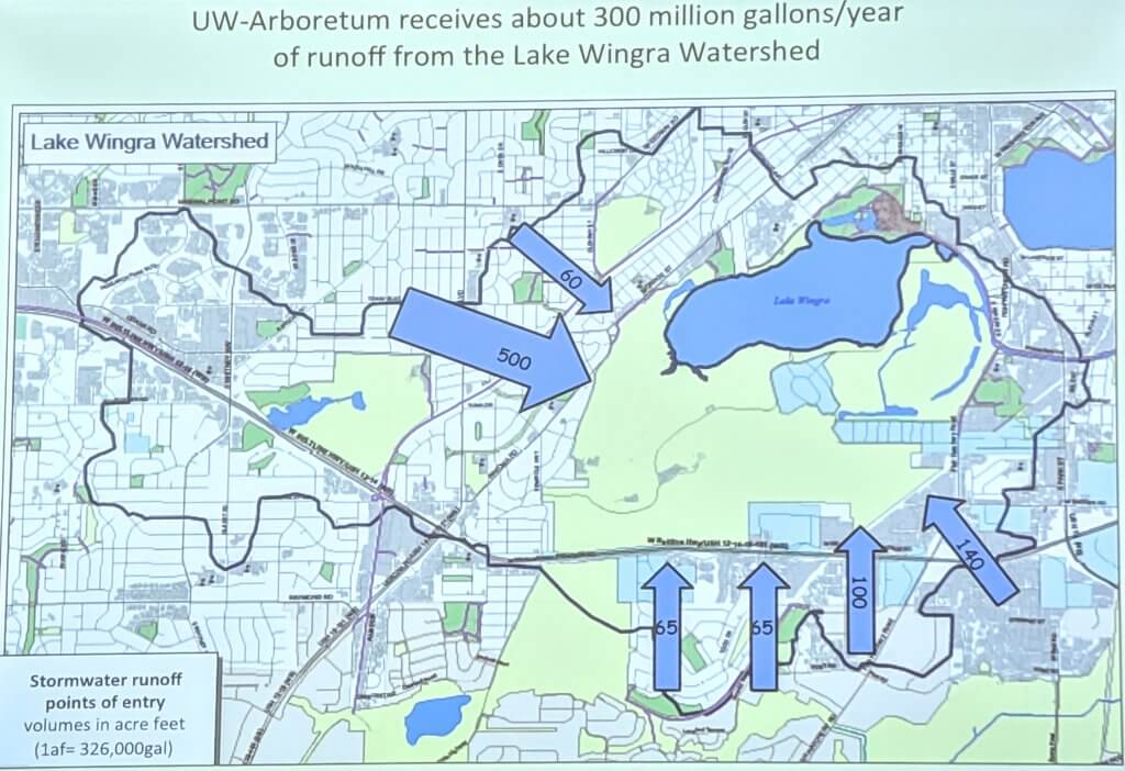
The UW-Arboretum receives about 300 million gallons of stormwater runoff from the Lake Wingra Watershed – EACH YEAR! This has caused landscape and ecosystem damage, and without a management strategy, the erosion and damage will continue to occur.
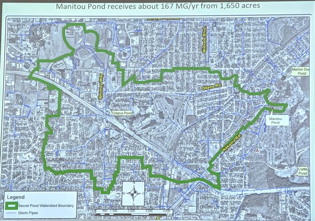
Guidelines to improve stormwater management at the Arboretum evolved in 2007. The goal was to eliminate further degradation of the ecosystem and natural areas caused by stormwater runoff. Out of these guidelines came the construction of Manitou Pond.
Manitou Pond
Manitou Pond was designed to look natural, and serves to handle stormwater before the water is transferred to Lake Wingra. The pond receives about 167 million gallons of stormwater runoff per year from 1,650 acres of the watershed. Because of the filtering properties of the pond and its surrounding vegetation, water moves toward Lake Wingra in a cleaner condition.
Liebl explains how drainage to our Yahara Lakes is poor because it’s a glacial lake system that is fairly flat. We saw flooding in late August 2018 that caused significant damage, and some of that damage remains in areas near the Arboretum. Continued stormwater management is necessary for both the Arboretum and for the entire watershed.
Read more about the construction of Manitou Pond.
Read more about the Yahara Watershed Academy.