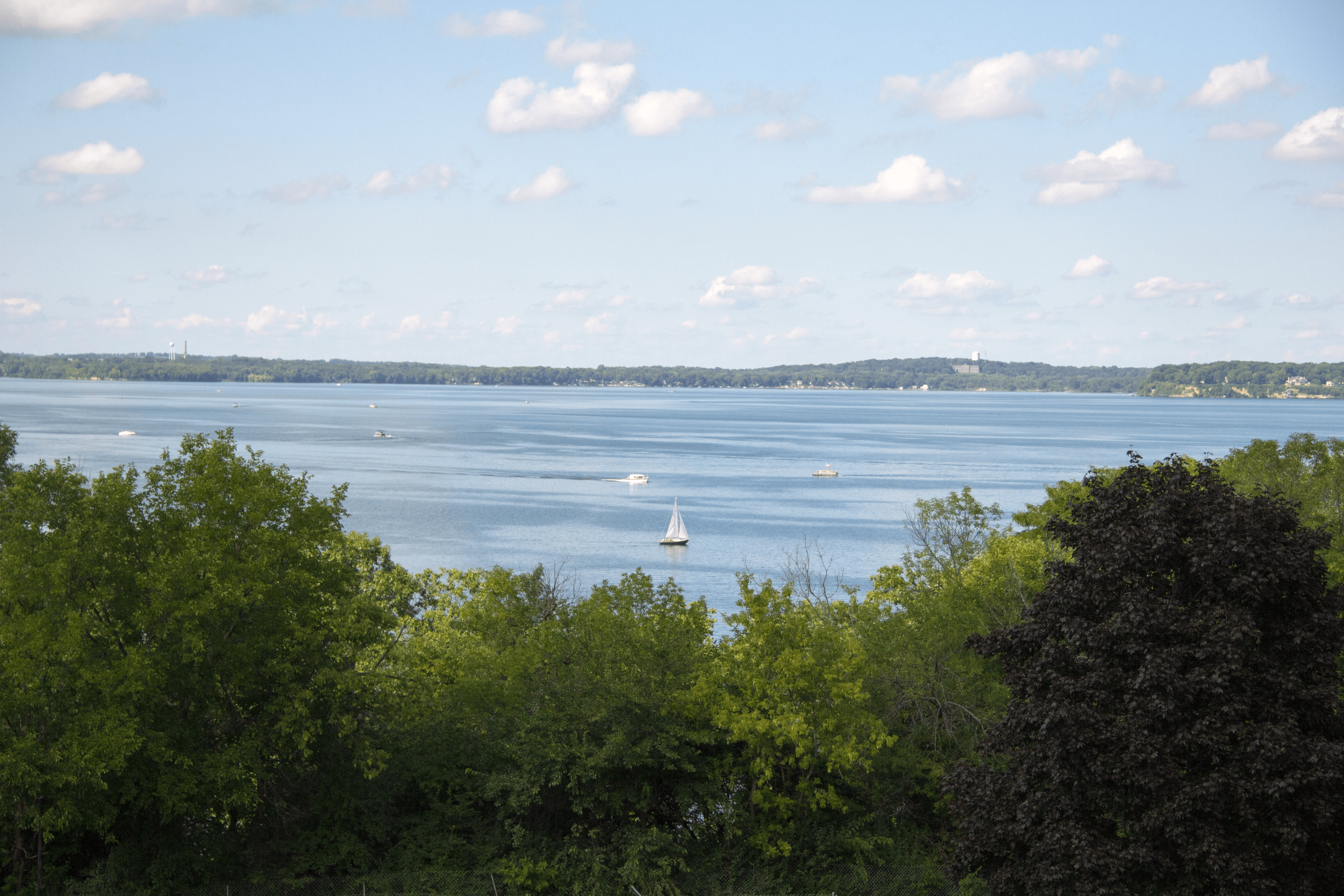
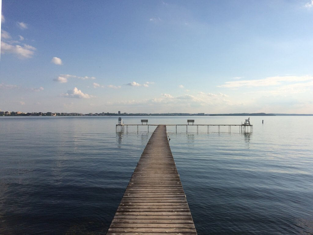
Lake Mendota
Lake Mendota is the largest and deepest lake in the Yahara chain of lakes. The lake is surrounded by mostly agricultural land with areas of rapid urban growth.
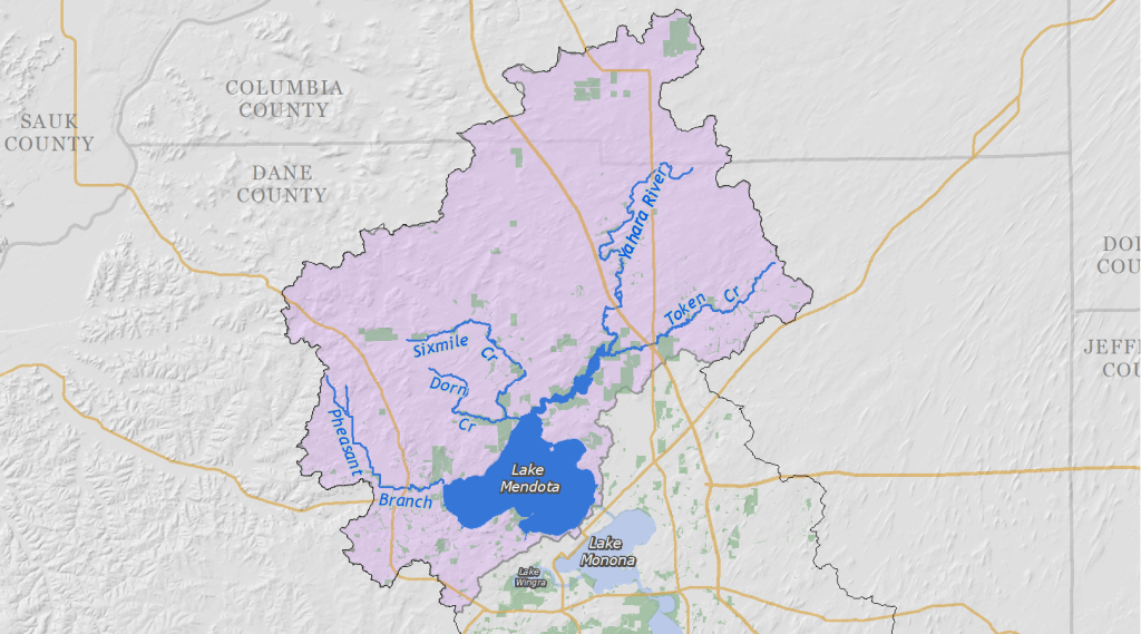
The north end of the Yahara Watershed, to the north of Lake Mendota, is known for fertile soils and multi-generational dairy farms. The University of Wisconsin-Madison and the Madison downtown lie along the southern shore of Lake Mendota, although much of the isthmus and downtown area drains into Lake Monona or Lake Wingra.
Major tributaries feeding into Lake Mendota include, from west to east, Pheasant Branch Creek, Dorn Creek, Sixmile Creek, the Yahara River, and Token Creek. Nutrients that flow into the later are carried down the chain of lakes via the Yahara River and represent the largest source of excess nutrients in the lower lakes.
In urban areas of the Mendota Watershed, most of the phosphorus reductions will come from better controls on construction erosion, leaf management, and stabilizing waterway banks to reduce erosion. In rural areas, most phosphorus reduction will come from improved agricultural practices including cropping and nutrient management.
To improve water quality in Lake Mendota, the Yahara CLEAN plan calls for reducing phosphorus runoff from both urban and rural areas. Improvements to reduce phosphorus loading into the lae will help improve water quality in the other three lakes in the chain (Monona, Waubesa, and Kegonsa) by reducing the amount of phosphorus flowing to the lower lakes via the Yahara River.
Lake Mendota by the numbers
The lake is 82 feet at its deepest, known as the “deep hole” between Picnic Point and Maple Bluff. Water in Lake Mendota moves slowly, replenishing every 4.4 years.
- Watershed area: 72,094 acres
- Surface area: 9,842 acres
- Shoreline: 22 miles
- Public beaches: 8
- Maximum depth: 82 feet
- Mean depth: 42 feet
- Flushing rate: 4.4 years
How was the water (2019)?
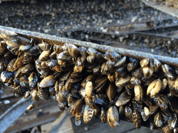
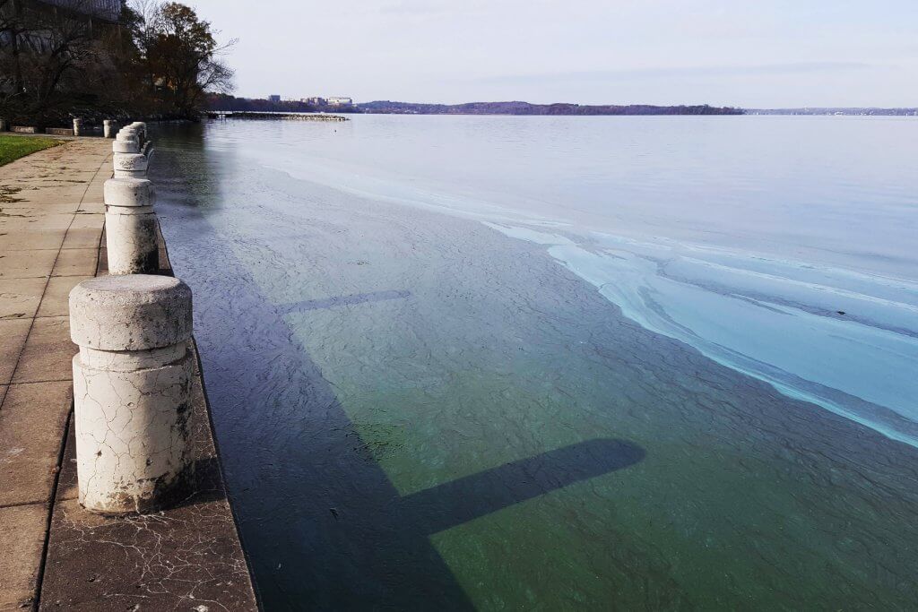
A reproducing population of zebra mussels was first confirmed in the lake in 2015. Zebra mussels filter out small forms of free-floating algae (phytoplankton), making the water clearer at the center of the lake, but prefer not to eat cyanobacteria, helping this organism proliferate near the shoreline. They are most likely contributing to increases in cyanobacteria blooms, beach closures, and the accumulation of algal mats that wash up on downwind shorelines.
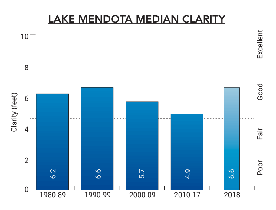
2019 average (July – August) water clarity ranked “good” and phosphorus concentrations ranked “fair,” according to Wisconsin DNR criteria for deep lakes.
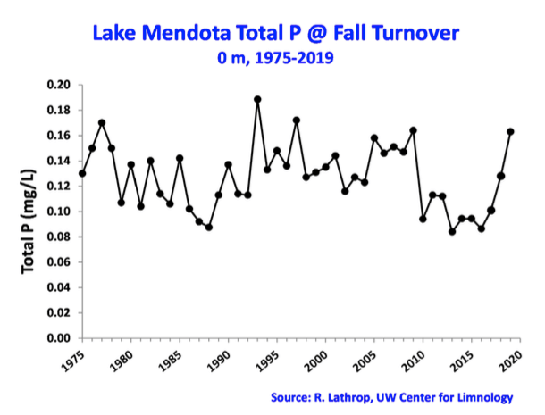
Lake Mendota Total Phosphorus at Fall Turnover (surface measurement, 1975-2019). Fall turnover is when the lake mixes from top to bottom due to temperature changes in the water. This is the time when phosphorus concentrations are most uniform in the lake. Concentrations were low during 2010-2017. Concentrations went up in both 2018 and 2019 due to high phosphorus loading from the lake’s major tributaries.
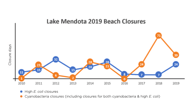
Lake Mendota beaches were closed 63 times during the summer of 2019, primarily due to cyanobacteria blooms or both cyanobacteria and high E. coli (64%). A total of eight Lake Mendota beaches are monitored.
2019 Community projects & initiatives
- City of Middleton repaired damage to the Donna Drive Pond, including reinforcing the embankment, improving the outlet system, and enlarging the pond to provide more flood-storage capacity.
- Friends of Pheasant Branch Conservancy is continuing to work with the City of Middleton and Dane County to repair and restore the Pheasant Branch Creek corridor after it was impacted by the devastating floods of August 20-21, 2018.
- Dane County provided funding for a new “Continuous Cover Program” to offer small family farms an incentive to convert lands from annual row crops into perennial grasses to improve water quality and reduce flooding.
- Town of Westport completed a project to control bank erosion along Six Mile Creek, a Lake Mendota tributary stream.
- Village of DeForest constructed five bio-retention basins at the Conservancy Place Athletic Complex. Wetland restorations continued at the Marvin and Marie Schweer’s Natural Area and along the Upper Yahara River Trail.
Organizations supporting Lake Mendota
The following groups work on water quality issues in the Lake Mendota watershed. Consider contacting an organization near you to get involved!
- City of Madison
- City of Middleton
- Dane County
- Friends of Cherokee Marsh
- Friends of Pheasant Branch
- Madison Water Utility
- Public Health Madison & Dane County
- UW-Madison Center for Limnology
- Village of DeForest
- Yahara Pride Farms
- Yahara Watershed Improvement Network
- Friends of the Yahara River Headwaters
Read about the other lakes of the Yahara Watershed
Here’s how Lake Mendota faired in previous years:
Lake Mendota 2018
How was the water?
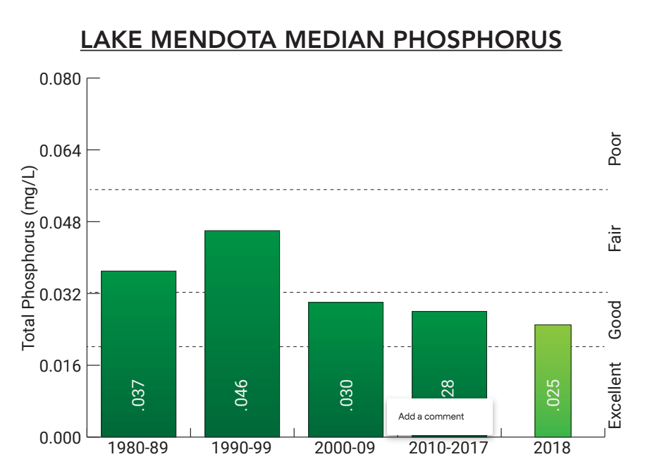
In 2018, total phosphorus levels and water clarity were “good” in the middle of the lake, according to DNR criteria. However, the 18 citizen monitor reports of cyanobacteria blooms were above the 4-year summer median of 7.5.
Data WDNR (1975-1994), NTL-LTER (1995-2018)
Phosphorus levels (2018 data)
- 0.025 mg/L or “good” according to DNR criteria for deep lakes
Data WDNR (1975-1994), NTL-LTER (1995-2018)
Beaches (2018 data)
- Closed 23% of the time and open 77% of the time
- 60 closure days due to cyanobacteria (blue-green algae)
- 7 closure days due to E. coli bacteria
- 11 closure days due to cyanobacteria and E. coli
- 104 closure days due to flooding
In contrast to the conditions in the middle of the lake, a large number of cyanobacteria blooms closed beaches located on the nearshore of the lake. Based on data collected by Public Health Madison & Dane County, Lake Mendota beaches were closed a record number of 78 days from Memorial Day to August 20th, compared to the summer 2010-17 median of 35 days for the whole summer. After August 20th, all the beaches were closed for the remainder of the season (August 21 – Labor Day) due to flood conditions.
What’s new on Lake Mendota?
Lake Mendota summer water quality conditions are now linked to the recent invasion of zebra mussels. The full effect of zebra mussels in the Yahara lakes is still uncertain. Results from other infested lakes suggest increases in water clarity in the middle of the lakes will occur. However, shoreline management problems could get worse from increased aquatic plant growth, and possible increases in filamentous algae and scums of cyanobacteria. Summer water quality in 2018 was also impacted by the unusual amount of flow into and out of the lake resulting from above normal precipitation in the region.
2018 Lake Mendota projects
- Dane County, Yahara WINS, and Clean Lakes Alliance continued support for a pilot project at nine farms testing manure composting. The project by Yahara Pride Farms will reduce pathogens and help farmers manage manure in the winter by composting instead of winter spreading.
- Yahara Pride Farms continued to implement cost-effective, farmer-led practices to protect soil and water quality. YPF also piloted innovative practices like manure composting.
- Dane County
- Worked with farmers to implement practices that divert phosphorus from the lake
- Granted funds to help permanently protect 95.5 wetland acres near the Fishery Area and to help purchase a 100.9 acre farm, with 10.9 acres purchased and easements on 90 acres for the Cherokee Marsh Natural Resource Area
- Permanently protected 11 acres in Token Creek County Park and Natural Resource Area
- Removed 2.7 miles of phosphorus-laden legacy sediment from Dorn Creek as part of the “Suck the Muck” project
- Began construction on a $1.6 million nutrient concentration system at the Middleton digester. The digester will further treat and filter manure utilizing reverse osmosis technology, and reduce the risk of phosphorus runoff
- City of Madison approved $2.36 million to purchase a 31-acre addition to Cherokee Marsh
- Village of DeForest
- Constructed 12 public/private stormwater facilities, maintained a 40-acre wetland in the Marvin & Marie Scheweers Natural Area, and restored wetlands in Reigstand Park
- Maintained a high-quality sedge meadow along the Yahara River Trail
Friend group projects for the watershed
- Friends of Cherokee Marsh maintained 95 acres with a prescribed burn at Yahara Heights Park and continued to collect critical information on stream health as part of the Yahara WINS volunteer monitoring program.
- Friends of Pheasant Branch Conservancy evaluated the feasibility of a carp bubble barrier system in Pheasant Branch Creek through a Clean Lakes Grant.
- The UW-Madison Lakeshore Nature Preserve worked with staff to remove woody invasive plants from 17 acres, sow native seed on 11 acres, and control invasive garlic mustard plants on more than 50 acres of the 300-acre reserve.
Lake Mendota 2017
Water clarity (2017)
- 4.9 feet or "good" according to DNR criteria for deep lakes
Phosphorus levels (2017)
- 0.036 mg/L or "fair" according to DNR criteria for deep lakes
Beaches (2017)
- Open 96% of the time and closed 4% of the time
- 7 closure days due to E.coli bacteria
- 24 closures due to cyanobacteria (blue-green algae)
- After an excellent 2016 beach season, Lake Mendota’s beaches lost 31 out of a total 792 possible beach days in 2017 (99 days multiplied by 8 beaches), which is a return to the long-term median. Closures were primarily due to cyanobacteria (blue-green algae); Tenney Beach and the Memorial Union Pier lost the most days.
Lake Mendota 2017 news
The explosion of zebra mussels was the big news for Lake Mendota, which has the potential to drastically change the lake and its shoreline. According to scientists at the UW Center for Limnology, we can likely expect more green, filamentous algae to grow in thick mats along the shoreline (read "Zebra mussel invasion in full swing in Lake Mendota"; "Zebra mussels transforming depths of Lake Mendota")
Other big news was the 2017 blue-green algal bloom that colored Lake Mendota from Picnic Point to the Yahara River and into Lake Monona on Father's Day weekend. According to the Center for Limnology, the warm, calm conditions and phosphorus levels created the perfect conditions for the bloom and resulting fish kill (read "Madison in Bloom: Blue-green algae hits Lake Mendota.")
With these changes in lake ecology, managing runoff will be more important than ever to mitigate the impact of zebra mussels and blue-green algae.
Lake Mendota 2016
Water clarity (2016)
- 7.2 feet or "good/excellent" according to DNR criteria for deep lakes
Phosphorus levels (2016)
- 0.022 mg/L or "good/excellent" according to DNR criteria for deep lakes
Beaches (2016)
- 8 closure days due to E. coli bacteria
- 0 closures due to cyanobacteria (blue-green algae)
- 0 closures due to the combination of E. coli and cyanobacteria
Lake Mendota 2015
Water clarity (2015)
- 4.9 feet or "good" according to DNR criteria for deep lakes
Phosphorus levels (2015)
- 0.030 mg/L or "good" according to DNR criteria for deep lakes
Beaches (2015)
- 28 closure days due to E. coli bacteria
- 20 closures due to cyanobacteria (blue-green algae)
- 1 closure due to the combination of E. coli and cyanobacteria
Lake Mendota 2014
Water clarity (2014)
- 4.9 feet or "good" according to DNR criteria for deep lakes
Phosphorus levels (2014)
- 0.030 mg/L or "good" according to DNR criteria for deep lakes
Beaches (2014)
- 28 closure days due to E. coli bacteria
- 20 closures due to cyanobacteria (blue-green algae)
Lake Mendota 2013
Water clarity (2013)
- 4.6 feet or "fair" according to DNR criteria for deep lakes
Phosphorus levels (2013)
- 0.026 mg/L or "good" according to DNR criteria for deep lakes
Lake Mendota 2012
Water clarity (2012)
- 5.6 feet or "good" according to DNR criteria for deep lakes
Phosphorus levels (2012)
- 0.018 mg/L or "excellent" according to DNR criteria for deep lakes